Twin Cities Future Transit Map
-
min-chi-cbus
- Capella Tower
- Posts: 2869
- Joined: June 1st, 2012, 9:19 am
Re: Twin Cities Future Transit Map
There's not a planned station along Broaday in North Minneapolis? I thought there was...
-
mattaudio
- Stone Arch Bridge
- Posts: 7759
- Joined: June 19th, 2012, 2:04 pm
- Location: NORI: NOrth of RIchfield
Re: Twin Cities Future Transit Map
OK, I am starting to think this thread is going in two different directions. I thought visualizer was trying to map out transit lines that are planned and likely to happen sometime in the next decade or two. We've had plenty of other threads for fantasy transit maps, and I hope Visualizer would also bring some of his awesome ideas to those, but I'm wondering if these parallel efforts should keep defined scopes?
It seems like some proposed changes (which are in no way being planned) are embraced, while others are disregarded since they are in no way being planned.
It seems like some proposed changes (which are in no way being planned) are embraced, while others are disregarded since they are in no way being planned.
-
Visualizer

- Nicollet Mall
- Posts: 180
- Joined: November 26th, 2012, 5:09 pm
- Location: @kyrilnegoda
Re: Twin Cities Future Transit Map
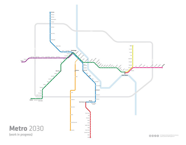
With a couple of variations, here's everything I'm considering

Twin Cities Transit Map 2030 : Order Prints | Follow Mapping Twin Cities on Tumblr |
-
Visualizer
- Nicollet Mall
- Posts: 180
- Joined: November 26th, 2012, 5:09 pm
- Location: @kyrilnegoda
Re: Twin Cities Future Transit Map
In addition to the routes shown on the above map, I'm also mapping higher frequency service corridors, be it the aBRT, streetcar or just regular frequent city bus routes (mode of transportation is irrelevant in this case).
Twin Cities Transit Map 2030 : Order Prints | Follow Mapping Twin Cities on Tumblr |
-
mattaudio
- Stone Arch Bridge
- Posts: 7759
- Joined: June 19th, 2012, 2:04 pm
- Location: NORI: NOrth of RIchfield
Re: Twin Cities Future Transit Map
Ohhh! So the yellow line is just interlining to St. Paul where it turns north to WBL? Makes more sense when I see the map above.
But Visualizer, don't let us keep you from the "dreamer" maps too! We need those to know what we COULD have!
But Visualizer, don't let us keep you from the "dreamer" maps too! We need those to know what we COULD have!
-
Visualizer
- Nicollet Mall
- Posts: 180
- Joined: November 26th, 2012, 5:09 pm
- Location: @kyrilnegoda
Re: Twin Cities Future Transit Map
The plan right now is to interline the "yellow" line with the Green line to Snelling where it turns north to Rosedale Shopping Center and on to WBL. This essentially eliminates the need for the Snelling BRT.
Does anyone else think this alignment is more likely or should we stick with mattaudio's proposal instead?
Does anyone else think this alignment is more likely or should we stick with mattaudio's proposal instead?
Twin Cities Transit Map 2030 : Order Prints | Follow Mapping Twin Cities on Tumblr |

Re: Twin Cities Future Transit Map
"Speicherstadt" - I love it! But assuming you're going to build a transit tunnel to accommodate the third line, wouldn't you want to consolidate the Nicollet & Hennepin stations into one? I always assumed that they just built two stations a block apart because otherwise the parking ramp between them would have to be modified/closed. Which is kinda dumb, but par for the course. Anyway, if you're tunneling already I'd think you'd put the platform between Hennepin & Nicollet with entrances on each.
"Who rescued whom!"
-
Visualizer
- Nicollet Mall
- Posts: 180
- Joined: November 26th, 2012, 5:09 pm
- Location: @kyrilnegoda
Re: Twin Cities Future Transit Map
Glad somebody was paying attention."Speicherstadt" - I love it!
The bold text indicates transfer station. The yellow line in reality will share the track with green and blue lines. This is the Vignelli style: *
http://www.designboom.com/tools/WPro/im ... b/map3.jpg
Major hubs like the Interchange are depicted with a white bubble
* Demonstration purposes only. Subject to change
Twin Cities Transit Map 2030 : Order Prints | Follow Mapping Twin Cities on Tumblr |
Re: Twin Cities Future Transit Map
There isn't capacity on 5th St. for another line beyond the Blue and Green lines. It would have to be a different alignment through downtown, or a subway.The bold text indicates transfer station. The yellow line in reality will share the track with green and blue lines. This is the Vignelli style: *
I, too think that at least one version of this map should be kept for projects that are actively being planned, and have at least a reasonable chance of being built in the next 2 decades.
My flickr photos.
-
mattaudio
- Stone Arch Bridge
- Posts: 7759
- Joined: June 19th, 2012, 2:04 pm
- Location: NORI: NOrth of RIchfield
Re: Twin Cities Future Transit Map
I think there's room for two forks of this... one being the actual map being planned (heck, even Metro Transit posted a "planned" map downtown) since it makes sense for better mapmaking to have a real impact on our transit usability in the near term. The other fork would be to explore possibilities for future alignments, etc.
Re: Twin Cities Future Transit Map
I agree. This map is great but keeping it within the Met Council Vision is realistic. I would also like to see Amtrak and Northstar on the map, which connect the region to the rest of the world.I, too think that at least one version of this map should be kept for projects that are actively being planned, and have at least a reasonable chance of being built in the next 2 decades.
-
Visualizer
- Nicollet Mall
- Posts: 180
- Joined: November 26th, 2012, 5:09 pm
- Location: @kyrilnegoda
Re: Twin Cities Future Transit Map
I think there's room for two forks of this... one being the actual map being planned (heck, even Metro Transit posted a "planned" map downtown) since it makes sense for better mapmaking to have a real impact on our transit usability in the near term. The other fork would be to explore possibilities for future alignments, etc.
Right now there is no plan to release two separate maps. I will be releasing this map under CC, you will be welcome to introduce your own modifications to it.
In regards to the ongoing project, the goals have been amended.
Still up for inclusion are all existing and planned LRT as well as numerous BRT, aBRT/streetcar and high-frequency bus routes.
For it to be a true future map, I also believe there should be enough room left for a debate outside what's already under consideration by the MT. Hence the inclusion of the two "wild card" lines, the Yellow and Purple lines. These are more speculative in nature and may not necessarily reflect any official plans.
Hope this helps clarify things up a bit.
Twin Cities Transit Map 2030 : Order Prints | Follow Mapping Twin Cities on Tumblr |
Re: Twin Cities Future Transit Map
You dont need a route to WBL down University Ave to justify a route down Snelling. The road alone is busy enough to support its own line. You could even extend it north to the army lands if they end up building something big there. Once a new study is done on the original WBL corridor, the route wont seem so far fetched.
I would love to see that Lake Street line extended to downtown St. Paul as well. If Minneapolis starts building streetcars then St. Paul will surely follow.(hopefully)
I would love to see that Lake Street line extended to downtown St. Paul as well. If Minneapolis starts building streetcars then St. Paul will surely follow.(hopefully)
-
Visualizer
- Nicollet Mall
- Posts: 180
- Joined: November 26th, 2012, 5:09 pm
- Location: @kyrilnegoda
Re: Twin Cities Future Transit Map
From the WBL LRT study doc:
Does that mean the proposed LRT would interline with the Central corridor all the way to downtown Minneapolis?7.5 Light Rail Transit Alternatives
Following the initial ridership model runs for both BRT and LRT it became apparent that the majority of
LRT Alternative 1 riders were boarding and alighting in closer to the St. Paul CBD rather than at the
Union Depot. In an attempt to better serve this market, LRT Alternative Modified 1B was developed.
This LRT sub-option has the same proposed stations and alignment from Metropolitan State University
north as LRT Alternative 1B. However, the alignment in downtown St. Paul would share tracks with the
future Central Corridor LRT, rather than terminate at the Union Depot. To achieve this, headways for
Modified LRT 1B were modified to match those of Central Corridor LRT.
Twin Cities Transit Map 2030 : Order Prints | Follow Mapping Twin Cities on Tumblr |
Re: Twin Cities Future Transit Map
There are 2 different WBL studies, One leading through Roseville and Northeast to Mpls and one heading south through Maplewood to StP. The line heading south through Maplewood will pass union station but will still likely end in downtown.
-
Visualizer
- Nicollet Mall
- Posts: 180
- Joined: November 26th, 2012, 5:09 pm
- Location: @kyrilnegoda
Re: Twin Cities Future Transit Map
Makes sense. Thanks!
Twin Cities Transit Map 2030 : Order Prints | Follow Mapping Twin Cities on Tumblr |
-
mattaudio
- Stone Arch Bridge
- Posts: 7759
- Joined: June 19th, 2012, 2:04 pm
- Location: NORI: NOrth of RIchfield
Re: Twin Cities Future Transit Map
It would pass union station then interline west to Minneapolis and Eden Prairie, at least I'm assuming because of this:
"To achieve this, headways for Modified LRT 1B were modified to match those of Central Corridor LRT."
"To achieve this, headways for Modified LRT 1B were modified to match those of Central Corridor LRT."
-
Visualizer
- Nicollet Mall
- Posts: 180
- Joined: November 26th, 2012, 5:09 pm
- Location: @kyrilnegoda
Re: Twin Cities Future Transit Map
Here's a map view with just the Metro routes shown. I'm happy with how everything turned out, and at this point, I don't expect any major changes. The yellow line could still use several tweaks, however.
DOWNLOAD FULL MAP
Key:
Purple BRT: I394 to Mound (Roughly corresponds to the present bus route 675)
Blue LRT: Hiawatha, Bottineau
Orange BRT: Hwy 35W
Red BRT: Cedar Ave
Green LRT: Central, Southwest
Yellow LRT: Union to Maplewood (Beam Ave)
Pink BRT: Gateway
feedback_04_Metro_only by -plasticboy-, on Flickr
Twin Cities Transit Map 2030 : Order Prints | Follow Mapping Twin Cities on Tumblr |
-
Visualizer
- Nicollet Mall
- Posts: 180
- Joined: November 26th, 2012, 5:09 pm
- Location: @kyrilnegoda
Re: Twin Cities Future Transit Map

Twin Cities Transit Map 2030 : Order Prints | Follow Mapping Twin Cities on Tumblr |
-
twincitizen
- Moderator
- Posts: 6380
- Joined: May 31st, 2012, 7:27 pm
- Location: Standish-Ericsson
Re: Twin Cities Future Transit Map
Looks great. It would require a lot of reworking on the south end, but I feel like the Minnesota river should be included as well. It is like THE defining feature of the south metro and what makes everything in Dakota County seem so far away. It is a strong geographic cue and would break up the swath of white down there.
I'd totally understand if you don't want to do it because it would require some re-spacing of Red & Orange Line stations, and some repositioning of the southern end of the Blue Line stations.
South of 494, the Orange Line stations should be American Blvd, 98th St, [Minnesota River goes here] Burnsville Transit Station, Burnsville Center, Lakeville (Kenrick Ave).
On the east end of the map, your "494" label should be south of the Pink Line. North of the Pink Line it becomes 694.
Last edited by twincitizen on December 19th, 2012, 10:32 pm, edited 2 times in total.
Who is online
Users browsing this forum: Bing [Bot] and 149 guests