Oh the 4...the super busy bus line that will never get any love from Metro Transit or the city because it's not Hennepin or Nicollet. Single tear. (I've been a daily 4 rider for almost two years)
FWIW, the portion of the 4 from the river all the way to 38th Street actually fits the criteria for the hi-frequency network. Metro Transit said they stopped updating that map during the ongoing threat of budget cuts in recent years. The 4 is just a bus or two away from *not* being "hi-frequency".
Back to the map, I would totally support a rapid bus line denoting the 4, from downtown to 50th Street, where it would meet with Route 46. On that note, if the Route 46 is going to be on the map, please extend it over to 50th & France so it can cross paths with the other routes (and denote 50th and France as a significant area).
Twin Cities Future Transit Map
-
twincitizen
- Moderator
- Posts: 6388
- Joined: May 31st, 2012, 7:27 pm
- Location: Standish-Ericsson
-
Visualizer

- Nicollet Mall
- Posts: 180
- Joined: November 26th, 2012, 5:09 pm
- Location: @kyrilnegoda
Re: Twin Cities Future Transit Map
I really need to be wrapping this up, so ... I will simply include all routes operating every 20 or fewer minutes or roughly 1/2 the frequency of the Green Line. Sound good?

Twin Cities Transit Map 2030 : Order Prints | Follow Mapping Twin Cities on Tumblr |
-
Visualizer
- Nicollet Mall
- Posts: 180
- Joined: November 26th, 2012, 5:09 pm
- Location: @kyrilnegoda
Re: Twin Cities Future Transit Map
You will be pleased to know that the 4 will be added in the next update.To me, the map looks a little empty without the 4.
Twin Cities Transit Map 2030 : Order Prints | Follow Mapping Twin Cities on Tumblr |

Re: Twin Cities Future Transit Map
I used to be too, before moving to Chicago. 4 love!Oh the 4...the super busy bus line that will never get any love from Metro Transit or the city because it's not Hennepin or Nicollet. Single tear. (I've been a daily 4 rider for almost two years)
-
Visualizer
- Nicollet Mall
- Posts: 180
- Joined: November 26th, 2012, 5:09 pm
- Location: @kyrilnegoda
Re: Twin Cities Future Transit Map
Bus network: thicker line = 10-15 min peak/base frequency, thin line = 20
Routes added or extended 4, 6, 46, 50.
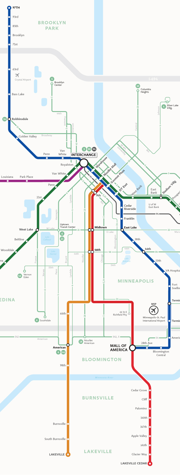
Routes added or extended 4, 6, 46, 50.
Twin Cities Transit Map 2030 : Order Prints | Follow Mapping Twin Cities on Tumblr |
-
Viktor Vaughn
- Target Field
- Posts: 593
- Joined: July 10th, 2012, 6:37 pm
Re: Twin Cities Future Transit Map
I love it. It gives Northeast form and adds Lyndale to the map making southside look like the densest area outside of downtown (rightly so). But mostly I like it because it suggests the 4 should offer decent service.You will be pleased to know that the 4 will be added in the next update.
-
Visualizer
- Nicollet Mall
- Posts: 180
- Joined: November 26th, 2012, 5:09 pm
- Location: @kyrilnegoda
Latest Map Update


I've added the remaining on my list bus routes in St. Paul. Something that has been low on priority list is commuter rail. Which isn't finished, but will be added back in the next update. Still need to create the HSR markers. I think East/West St. Paul are looking rather empty, is there something missing there?
DOWNLOAD LARGE MAP
Twin Cities Transit Map 2030 : Order Prints | Follow Mapping Twin Cities on Tumblr |
-
Visualizer
- Nicollet Mall
- Posts: 180
- Joined: November 26th, 2012, 5:09 pm
- Location: @kyrilnegoda
Attention mapping geeks! 
I plan on printing a couple of large maps in the coming days. Anyone interested in seeing it in person? I will be available for a show and tell next week or the week after. Lemme know!
I plan on printing a couple of large maps in the coming days. Anyone interested in seeing it in person? I will be available for a show and tell next week or the week after. Lemme know!
Twin Cities Transit Map 2030 : Order Prints | Follow Mapping Twin Cities on Tumblr |
-
Visualizer
- Nicollet Mall
- Posts: 180
- Joined: November 26th, 2012, 5:09 pm
- Location: @kyrilnegoda
Twin Cities Future Transit Map
Here's the latest. Minor fixes + map legend

Download Large Map

Download Large Map
the metro brt icons are missing from the legend as is the proper copy
- moved the orange and red lines at crosstown highway higher up. The 66th station marker stills needs to be relocated to align with the route 515.
- terminal bus stops no longer display route labels. They are redundant and only draw attention away from transfer stations
- "rapid" bus lines were made thicker (4 pts. lines) than "standard" bus routes, which remained at 2 pts.
- much of water geometry is still a little blah in my opinion. I plant to redo water with a more geographical appearance.
- both downtown areas suffer from readability issues. I'm considering taking them off this map altogether.
- removed the slight bend where red line crosses the river. I think that kind of detail is unnecessary.
- re-aligned the orange line stations south of the river
- commuter lines will not be shown on this map. I felt like including they provided little informational value for this particular map. Later on, it will be possible to make a regional overview showing commuter lines as well as HSR lines.
Download Large Map
Download Large Map
the metro brt icons are missing from the legend as is the proper copy
- moved the orange and red lines at crosstown highway higher up. The 66th station marker stills needs to be relocated to align with the route 515.
- terminal bus stops no longer display route labels. They are redundant and only draw attention away from transfer stations
- "rapid" bus lines were made thicker (4 pts. lines) than "standard" bus routes, which remained at 2 pts.
- much of water geometry is still a little blah in my opinion. I plant to redo water with a more geographical appearance.
- both downtown areas suffer from readability issues. I'm considering taking them off this map altogether.
- removed the slight bend where red line crosses the river. I think that kind of detail is unnecessary.
- re-aligned the orange line stations south of the river
- commuter lines will not be shown on this map. I felt like including they provided little informational value for this particular map. Later on, it will be possible to make a regional overview showing commuter lines as well as HSR lines.
Last edited by Visualizer on February 2nd, 2013, 11:43 pm, edited 3 times in total.
Twin Cities Transit Map 2030 : Order Prints | Follow Mapping Twin Cities on Tumblr |
Re: Twin Cities Future Transit Map
This needs to be sent to the legislature, metro transit and the met council. You could even get around this city without a car on most days! Where is this again? 
Re: Twin Cities Future Transit Map
Rosedale Center is in the city of Roseville.
Re: Twin Cities Future Transit Map
Why does it say "21" at the Interchange?
-
Visualizer
- Nicollet Mall
- Posts: 180
- Joined: November 26th, 2012, 5:09 pm
- Location: @kyrilnegoda
bus lines highlighted

Twin Cities Transit Map 2030 : Order Prints | Follow Mapping Twin Cities on Tumblr |
-
Visualizer
- Nicollet Mall
- Posts: 180
- Joined: November 26th, 2012, 5:09 pm
- Location: @kyrilnegoda
This or that
Need your opinion on something, guys.
Would you prefer to see a map with the street grid as shown below OR one without the grid and only the transit corridors labeled? In other words, the map can have more local context or less context.
bigger

Would you prefer to see a map with the street grid as shown below OR one without the grid and only the transit corridors labeled? In other words, the map can have more local context or less context.
bigger
Twin Cities Transit Map 2030 : Order Prints | Follow Mapping Twin Cities on Tumblr |
-
Tcmetro
- Wells Fargo Center
- Posts: 1781
- Joined: May 31st, 2012, 8:02 pm
- Location: Chicago (ex-Minneapolitan)
Re: Twin Cities Future Transit Map
Gotta admit, I like the grid. But then, I am a sucker for geographically accurate maps.
-
Visualizer
- Nicollet Mall
- Posts: 180
- Joined: November 26th, 2012, 5:09 pm
- Location: @kyrilnegoda
Re: Twin Cities Future Transit Map
It will still be diagrammatic. Just with an added familiarity of a google map
Many European maps favor abstraction, like this one of Leipzig's LVB network (trams+buses):

but the Spokane Transit Map looks just as nice, with the cross streets labeled:

Many European maps favor abstraction, like this one of Leipzig's LVB network (trams+buses):
but the Spokane Transit Map looks just as nice, with the cross streets labeled:
Twin Cities Transit Map 2030 : Order Prints | Follow Mapping Twin Cities on Tumblr |

Re: Twin Cities Future Transit Map
It does seem like you're gradually heading for this, right? Which, as a daily transit user, I can deal with fine. But when you add every little thing, you lose the brilliant simplicity of this. Just a thought.
Nick Magrino
[email protected]
[email protected]
-
Visualizer
- Nicollet Mall
- Posts: 180
- Joined: November 26th, 2012, 5:09 pm
- Location: @kyrilnegoda
Re: Twin Cities Future Transit Map
Interesting. I don't think the goal is making a usable, consumer-grade map. From the beginning, the goal was really to show the general alignment of future transit services in way that is uniquely illuminating. I'm trying to walk a thin line between making it comprehensive yet too complex for a casual reader to understand and too simple to be convincing.
Last edited by Visualizer on February 4th, 2013, 10:59 pm, edited 1 time in total.
Twin Cities Transit Map 2030 : Order Prints | Follow Mapping Twin Cities on Tumblr |
-
Visualizer
- Nicollet Mall
- Posts: 180
- Joined: November 26th, 2012, 5:09 pm
- Location: @kyrilnegoda
December-January work progress as a gif

Twin Cities Transit Map 2030 : Order Prints | Follow Mapping Twin Cities on Tumblr |
-
Visualizer
- Nicollet Mall
- Posts: 180
- Joined: November 26th, 2012, 5:09 pm
- Location: @kyrilnegoda
Re: Twin Cities Future Transit Map
3. Since we are talking 2030 (and beyond), lets go ahead and add the 38th Street Station to the Orange Line. I think this map is going to be really popular, and in a way we can use it to advance certain ideas/desires about transit in the region. If you add 38th Street Station, you can also add Route 23, if you don't think it will make the map too busy.
Took some effort to squeeze it in, but here you have it

Last edited by Visualizer on February 8th, 2013, 5:57 pm, edited 1 time in total.
Twin Cities Transit Map 2030 : Order Prints | Follow Mapping Twin Cities on Tumblr |
Who is online
Users browsing this forum: No registered users and 2 guests