Page 2 of 3
Re: Van White Memorial Bridge
Posted: June 2nd, 2013, 6:17 pm
by mulad
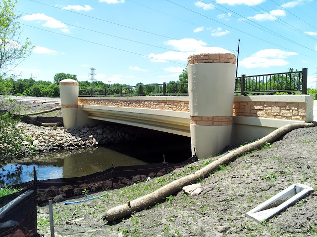
I wandered by today and took a few mostly boring photos with my phone. Here's the northern approach:

Small bridge over Bassett Creek:
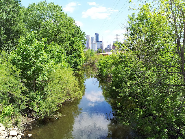
View from Bassett Creek bridge toward downtown:
Blurry shot of the bridge itself in the distance:

Re: Van White Memorial Bridge
Posted: July 31st, 2013, 8:42 am
by fehler
Is there an opening date? I've seen lane paint, they must be pretty close right now.
Re: Van White Memorial Bridge
Posted: July 31st, 2013, 10:43 am
by pfreyre
Is there an opening date? I've seen lane paint, they must be pretty close right now.
At the bottom of the project page
http://www.minneapolismn.gov/cip/all/WCMS1P-080728 it says " It is anticipated the road will be open to traffic by the end of August."
Re: Van White Memorial Bridge
Posted: August 1st, 2013, 12:37 pm
by mister.shoes
So I see that they are setting everything up for twin bridges but only building the one for now. Obviously, Dunwoody is a proper split boulevard at the moment. Is Fremont supposed to become the same at the north end at some point in the future?
Re: Van White Memorial Bridge
Posted: August 22nd, 2013, 9:37 am
by lordmoke
Re: Van White Memorial Bridge
Posted: August 22nd, 2013, 10:35 am
by MNdible
Now that this is done, how many wealthy Lowry Hill political donors will have to be slain before there's a real N-S connection between Dunwoody Blvd. and Kenwood Parkway?
Re: Van White Memorial Bridge
Posted: August 22nd, 2013, 12:51 pm
by seanrichardryan
They decided to keep the current alignment with last year's paving of the parade parkway. So really, this parkway simply dumps you onto a very long freeway off-ramp.
Re: Van White Memorial Bridge
Posted: August 27th, 2013, 12:36 am
by alleycat
Finally drove this today after coming back to north from Uptown. I don't get how it wasn't possible to properly connect the ice arena's new street directly to the bridge and create an intersection at Dunwoody. Then the 5 northsiders who even know it exists could've skipped the Lowry Tunnel area. It's completely half-assed at this point.
Re: Van White Memorial Bridge
Posted: August 27th, 2013, 9:07 am
by lordmoke
I'm not sure how widely known it is, but the city (and Ryan, apparently) have some seemingly lofty visions for the area around this bridge:
http://www.journalmpls.com/news/news/a- ... e-barriers
Re: Van White Memorial Bridge
Posted: August 27th, 2013, 11:28 am
by Nathan
This is the most updated information on the Linden Yards West (phase I planning)
http://www.ci.minneapolis.mn.us/www/gro ... 106414.pdf
Re: Van White Memorial Bridge
Posted: August 27th, 2013, 11:34 am
by alleycat
I know about the Bassets Creek development. This bridge was part of the Holman decree, which was meant to decentralize the poor in the Olson projects. This has to do with the segregation of the poor in the city. If you still can't easily get from the poor neighborhood (Near North Community) to the rich neighborhood (Kenwood, Lowry Hill) you still are hindering the commingling of these two areas and the classes. When a simple intersection isn't created that would help north and south siders get to the other area you put a big dent into the credibility of this project.
At the last Jordan board meeting I was discussing with our board director that the reason Bottineau is being built in the park is so that suburban riders won't have to commute through north proper. She, a black woman, told me that I was the first white person to be honest about the routing out loud. There's a parallel hear between the LRT alignment and the lack of a connection directly to the new parade ground road. Their are institutional decisions being made that continue to bastardize the northside and it's transit connections.
OK, now that I got that out of my system. It's built and it will be key to building out the Van White station for the SW LRT and it will be a vast improvement from biking on Lyndale's sidewalk from 7th Street to the Sculpture Gardens. Now there are four legitimate bike routes to Uptown via Van White, the Bryn Mawr Meadows pedestrian bridge, the awkward Penn-Kenwood Parkway connection along 394 and Theo Wirth parkway. So, for bikes this is pretty good.
The Basset's Creek development will only have a real reason to be if the SWLRT is built on the 3A alignment. I guess this is first time I've actually given that route legitimacy.
Update: Read through that plan for Linden Yards and it looks promising. The question I would have is how does it improve commerce on Glenwood. Will this be an island onto itself or truly integrate south and north?
Re: Van White Memorial Bridge
Posted: August 27th, 2013, 11:45 am
by orangevening
Nice. Looks like the trail gets move (again) though.

Re: Van White Memorial Bridge
Posted: August 27th, 2013, 3:03 pm
by mulad
Ugh, that all seems like such a bad idea to me. I suppose my sense of scale is thrown off by the fact they show it being developed in these big monolithic blocks, but the strip of land seems so narrow -- You could fit several copies of the old Kowloon Walled City into this space, but nobody wants to go within even a few orders of magnitude of that density. It's going to be pretty isolated unless they get really, really, lucky with retail tenants.
I also really want to reserve a good chunk of the "Phase II" space for a rail yard again -- it's one of the most logical places to put a layover facility for intercity and commuter trains serving The Interchange.
If the city *really* wants to get this area to develop, I'd have to suggest giving I-394 the "Big Dig" treatment by putting it underground through here (or removing it entirely) -- heck, the bike trails and LRT could go on top, since the highway tunnel probably wouldn't be the best place to stack tall buildings on top of.
Re: Van White Memorial Bridge
Posted: August 27th, 2013, 4:32 pm
by RailBaronYarr
Yeah, the whole thing just feels so... human scaled, what with all those giant parking structures. Seriously, this is not what I would call a slam-dunk win for developing more urban neighborhoods in Minneapolis, it's a secondary office park for suburban commuters (as evidenced by parking and office towers being focused first).
Re: Van White Memorial Bridge
Posted: August 27th, 2013, 10:10 pm
by Minnekid
Don't forget this isn't the finished project. Like they still have a lot of planning to do, and they may change the parking ramps to something else, how do we contact that development team. They said "Does this fulfill your expectations?" or something along those lines. Next, it won't be completely isolated once phase II and III would be built, especially that it has a park in front of it. Very nice.
Re: Van White Memorial Bridge
Posted: August 27th, 2013, 10:46 pm
by David Greene
Finally drove this today after coming back to north from Uptown. I don't get how it wasn't possible to properly connect the ice arena's new street directly to the bridge and create an intersection at Dunwoody. Then the 5 northsiders who even know it exists could've skipped the Lowry Tunnel area. It's completely half-assed at this point.
Many Northsiders know about the bridge. It's a BFD resulting from the Hollman Decree.
You can guess at the reason a proper connection to The Parade wasn't made.
Re: Van White Memorial Bridge
Posted: August 27th, 2013, 10:49 pm
by David Greene
Update: Read through that plan for Linden Yards and it looks promising. The question I would have is how does it improve commerce on Glenwood. Will this be an island onto itself or truly integrate south and north?
Lots of people are concerned about that. The Ryan development is just a piece of the BCV master plan. I don't believe the master plan itself touches Glenwood but there are definitely people in Harrison working on it.
Re: Van White Memorial Bridge
Posted: August 27th, 2013, 10:54 pm
by David Greene
I also really want to reserve a good chunk of the "Phase II" space for a rail yard again -- it's one of the most logical places to put a layover facility for intercity and commuter trains serving The Interchange.
It's a bad idea. Why put a rail yard next to a development when you're trying to revitalize the area?
Harrison residents are really pissed off about the rail yard proposal. They've managed to get the city to propose reserving only the easternmost 4.4 acres for study as a layover facility. Harrison is ready to accept that with some conditions on what happens if rail is not put there and various interim use ideas. They also ewant compensation if a rail yard is put there.
A rail yard is a problem because it reinforces the area as a place where the city dumps its garbage. It would further a pattern of structural racism in existance since at least 1935 and probably earlier.
Harrison residents are compromising A LOT by even considering a study of the 4.4 acres for layover. Let's see if the city recognizes that.
Re: Van White Memorial Bridge
Posted: August 28th, 2013, 2:26 am
by mulad
Ugh. What? I don't get this at all. Where do you suggest it should go? I think half of it would be under I-94 anyway, and the rest of it would be obscured by the big power substation. Sure, 4.4 acres is a lot when you're talking about an area that's only going to have 20 acres of developable area to start with, but this is entirely the problem.
This Bassett Creek plan is all backwards to me -- work on redeveloping empty parcels along Glenwood and North 2nd Street, as well as at least some parts of the impound lot (the "Phase III" area). If people can tolerate building next to the substation, the existing rail alignment could be shifted somewhat southeast, opening up several acres for development without being stuck between the tracks and the highway (and the rail yard could be shifted southwest into the "Phase I" area).
My experience is partly colored by living close to the Energy Park area of Saint Paul, which was a largely unused space in between two rail lines until the old NP Como shops (Bandana Square) were abandoned. The chunk by Midway Stadium is about twice as wide as this Linden Yards area, and it feels very awkward -- it doesn't help that they did a lot of it in the 1980s when sprawling suburban-style development was the norm, but looking back, it's debatable whether the area should have been developed much at all. The tracks mean that you're stuck going along Energy Park Drive to go anywhere.
Linden Yards does have good trail connectivity, but it's a stretch to call it walkable even though it's not that far from downtown. For instance, the downtown Lunds is close to a mile away, which I suppose is alright, but getting there requires going through the busy Hennepin/Dunwoody/7th/Lyndale intersection under I-94. Sure, people will ride bikes to some extent, but this spot is pretty dependent upon having an LRT stop if you want to avoid loading the place up with parking -- even then, I'm not quite sure where people would go to get their basics (the grocery at 222 Hennepin? That's not particularly close to LRT, though maybe a bus ride along Hennepin would work.)
Re: Van White Memorial Bridge
Posted: August 28th, 2013, 7:57 am
by David Greene
Ugh. What? I don't get this at all. Where do you suggest it should go? I think half of it would be under I-94 anyway, and the rest of it would be obscured by the big power substation.
It would not be under 94. It would be very close to the Van White station.
There are any number of places it should go. The first option should be to not build it. We don't need high speed rail to terminate in Minneapolis. We spent hundreds of millions on Union Depot. That is our intercity rail hub.
But it we really want to waste money duplicating service, there are any number of locations in Northeast or along the midway trunk line.
It's super important to understand the context here. Harrison is located in an area labeled "Negro Slums" on planning maps since at least 1935. There has been deliberate segregation, disinvestment and concentration of poverty in the area. These neighborhoods deserve a real investment, not more siting of polluting industrial uses.
This Bassett Creek plan is all backwards to me -- work on redeveloping empty parcels along Glenwood and North 2nd Street, as well as at least some parts of the impound lot (the "Phase III" area).
The impound lot isn't available yet. Developers are going to go where they want to go. Glenwood is going to take some time to get in shape.
Linden Yards does have good trail connectivity, but it's a stretch to call it walkable even though it's not that far from downtown. For instance, the downtown Lunds is close to a mile away, which I suppose is alright, but getting there requires going through the busy Hennepin/Dunwoody/7th/Lyndale intersection under I-94. Sure, people will ride bikes to some extent, but this spot is pretty dependent upon having an LRT stop if you want to avoid loading the place up with parking -- even then, I'm not quite sure where people would go to get their basics (the grocery at 222 Hennepin? That's not particularly close to LRT, though maybe a bus ride along Hennepin would work.)
Not much was walkable in this city until we made it so. Development takes time. The neighborhoods have been working on this for over a decade. It's not like this came out of nowhere without a plan. Maybe Phase II will include a grocery and retail. I mean honestly, the North Loop prospered for many years before having any sort of grocery or day-to-day retail nearby.