Page 5 of 14
Re: Google Maps
Posted: April 15th, 2015, 11:59 am
by mister.shoes
Hear hear. I hate the new Maps. 45° view 4 eva.
Re: Google Maps
Posted: May 5th, 2015, 12:03 pm
by grant1simons2
Finally got 3d vision for Minneapolis and St Paul
Re: Google Maps
Posted: May 5th, 2015, 12:21 pm
by MNdible
I was skeptical of the value of this, based on what I've seen rolled out in other areas, but I have to admit it's pretty bad-ass. Just looking at downtown Minneapolis, it seems like they've done a much better job in mapping things out than I've seen previously. It looks good, and also it's not tripped up by bridges over topography like I've seen previously.
Re: Google Maps
Posted: May 5th, 2015, 1:30 pm
by twincitizen
Maybe this has always been there, but the "measure distance" feature is hidden under right-click. They are slowly re-adding some, but not all, of the things I found useful in classic maps.
Still not available:
* Draw/drag a polygon to zoom on an area
* 45 degree toggle (though less useful if they have no intention of flying new angled imagery)
The thing I miss the most was the ability to search for numerous "shapes" (i.e. cities, neighborhoods, etc.) and have them display on the map simultaneously. In the "classic" upper-right corner toolbox thingie, you could check/uncheck those multiple features you wanted to display. It was like a mini-GIS tool in a way. It was extremely useful...to me anyways. Now you can only display one "shape" at a time...and geographic boundaries only display in "map" mode, not satellite imagery mode.
Re: Google Maps
Posted: May 6th, 2015, 8:55 am
by woofner
I've been looking for apartments in a remote city for the last couple weeks, and I had to switch to bing because google's 3d view doesn't come close to the detail of the classic oblique aerial. It's fine for traditional american downtowns and mountain ranges, but pretty much every other place type is distorted and fake looking. Boo, especially on all the gorgeous European cities they had great oblique aerial images for.
Re: Google Maps
Posted: May 6th, 2015, 10:24 am
by mulad
Just in case anyone is unaware, you can simulate a 45-degree view by clicking the "Tilt the view" button just below the compass in the lower-right corner of the Earth view. There's also a shallower view available by clicking the button a second time. The third click goes back to the 90-degree view. The arrows on either side of the compass let you rotate and see things from the south/north/east/west, though you can't use arbitrary angles like in the standalone Google Earth app.
I'm surprised that the skyways in both downtowns look pretty good. Most of them seem to be modeled as actual bridges rather than two-story buildings rising from the ground.
Re: Google Maps
Posted: May 6th, 2015, 10:52 am
by twincitizen
I had to zoom in really, really far to get the simulated oblique view on Desktop.
You can rotate the north axis around, but only in 90 degree chunks, not total 360 control like mobile.
It appears with the new 3D rendered imagery that you can zoom in much more closely than before. I can zoom in to the point where a 150' x 150' (like 3 Minneapolis lots) area nearly fills my screen. I don't recall being able to zoom in that close before.
I'm really liking the brighter colors of the lawns, rooftops, etc. with the rendered imagery. For contrast, head down to 76th Street in Richfield - this appears to be the southern cutoff point between the new rendered stuff and the plain 2D photography. The western cutoff appears to be France-ish with some additional territory covered in SLP and GV. The cutoff to the north is 75th Ave N. On the east, they only made it over to Earl St (inside St. Paul city limits!).
For an example of a skyway that was not properly modeled as a bridge, check out Fairview Southdale.
Re: Google Maps
Posted: May 6th, 2015, 5:18 pm
by woofner
Do I just have a shitty graphics card or something (because I do)? For me, there's no comparison. Even if bing doesn't zoom as far, it shows significantly more detail:
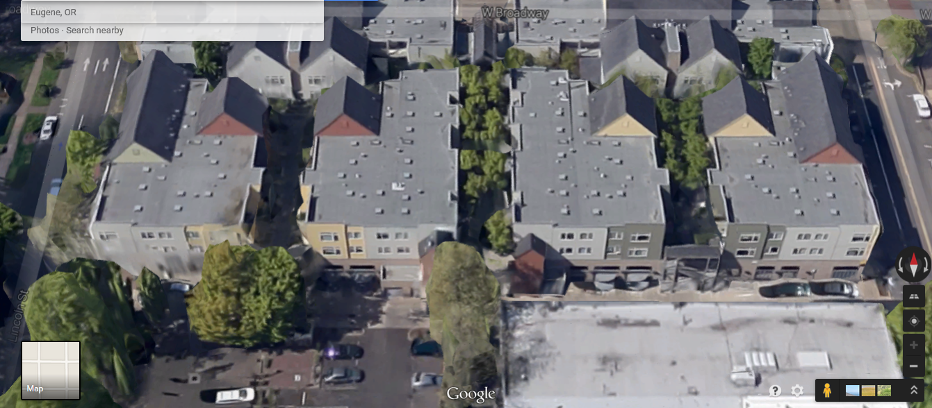
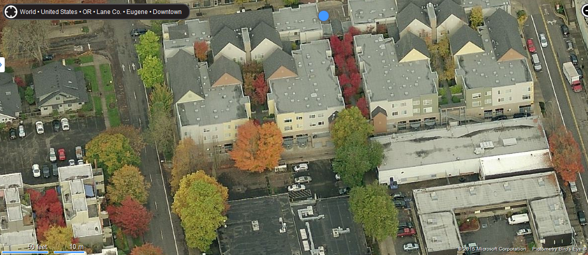
This slightly more popular location gets more detail from google, but the image is still blurry and washed out compared with the actual photo:

I just don't understand why it would be considered an improvement to have less detailed, uglier images.
Re: Google Maps
Posted: May 6th, 2015, 8:57 pm
by MNdible
I'm not saying it's an improvement over actual satellite photos, in terms of quality or crispness. I'm saying it's better than the earlier iterations of this that I've seen. Also, I think there's a trade-off in the ability to do real time panning, with live updating perspectives, etc. It's cool.
I definitely wish we still had access to the oblique aerials.
Re: Google Maps
Posted: May 7th, 2015, 7:36 am
by mulad
Hmm, I'm seeing that the 3D view has older imagery, at least over in St. Paul -- CHS field is shown as a hole in the ground, but if you have a browser where 3D is disabled or use
My Maps, the field is much further along in construction. The old Lafayette Freeway Bridge is also still there in the 3D view.
Personally, I've never been a big fan of the 45-degree views -- I usually turned them off in favor of the straight-down aerials. The ability to seamlessly pan around with the 3D view is nice, even though you sacrifice some image quality. Sometimes it just takes a while for the detail to all load in, though.
Re: Google Maps
Posted: May 7th, 2015, 7:44 am
by mulad
Huh. I'm also noticing that they did some processing to hide cars on highways and many streets -- vehicles mostly only show up if they've been parked long enough to be around for more than one pass by the aircraft that did the scanning.
Re: Google Maps
Posted: May 8th, 2015, 11:19 am
by Tiller
I just don't understand why it would be considered an improvement to have less detailed, uglier images.
This
is Google we're talking about. Why improve your services if everyone already uses them? (sarcasm/rhetorical)
Re: Google Maps
Posted: May 10th, 2015, 2:43 am
by Lancestar2
Is anybody else getting many paid advertisements located directly on the Google maps? Now that I'm forced to use the new maps since they discontinued classic I notice when I was searching for tanning salons downtown I got an advertisement that looked like a business downtown but when I clicked it, turned out to be somewhere in the suburbs. Seems pretty odd they would advertise in such an intrusive way. Does that happen to anyone else?
Re: Google Maps
Posted: May 11th, 2015, 12:07 pm
by mister.shoes
That's Google's business model in a nutshell: sell sell sell ads ads ads ads! Monetize eyeballs!
Re: Google Maps
Posted: June 17th, 2015, 7:32 am
by twincitizen
So before Google maps killed off the 45 degree imagery a year or so ago, the most recent 45 degree flyovers were taken in early 2011 (to the best of my recollection). The standard aerial imagery has since been updated twice, in fall 2012 and again in fall 2014.
BUT! There appears to be much more recent 45 degree imagery. The problem is accessing it, since you cannot do so through standard Google Maps.
Check this out though. In this Google Map embedded in an UrbanMSP post, if you zoom in far enough, it will actually switch to the new 45 degree imagery!!
https://forum.streets.mn/viewtopic.php?f=18& ... 100#p76197
What gives? Why are they still flying new 45 degree imagery if it's not accessible via regular Maps? I'm guessing it's an accident that it's accessible at all through these embedded maps.
Can anyone provide a link (or create a web page of their own) where one could use this backdoor to view the new 45 degree stuff in a larger window?
Re: Google Maps
Posted: June 17th, 2015, 9:09 am
by mister.shoes
I have to assume they're shooting 45° imagery to make their 3D views. I can't think of any other way to build up the textures that get applied to the 3D wireframes without shooting from the side. But for whatever reason (Apple Maps, I presume), Google has decided that the whiz-bang 3D spin-and-pan approach is a better user experience than high-res 45° images shot from [only] four different directions.
Re: Google Maps
Posted: June 24th, 2015, 10:00 am
by mattaudio
Is there any way to filter / show only paved roads? We have an abundance of 55 MPH rural paved county roads in Minnesota. Even though I think we have too many, I like to drive them in the meantime (especially to avoid congestion or to avoid routes with which I am bored). The problem is that they are not consistently named or numbered county to county, so I often have to plan routes ahead of time. I wish there was a way to filter routes this way. Any ideas?
Re: Google Maps
Posted: June 27th, 2015, 10:47 pm
by PigsEye
So before Google maps killed off the 45 degree imagery a year or so ago, the most recent 45 degree flyovers were taken in early 2011 (to the best of my recollection). The standard aerial imagery has since been updated twice, in fall 2012 and again in fall 2014.
BUT! There appears to be much more recent 45 degree imagery. The problem is accessing it, since you cannot do so through standard Google Maps.
Check this out though. In this Google Map embedded in an UrbanMSP post, if you zoom in far enough, it will actually switch to the new 45 degree imagery!!
https://forum.streets.mn/viewtopic.php?f=18& ... 100#p76197
What gives? Why are they still flying new 45 degree imagery if it's not accessible via regular Maps? I'm guessing it's an accident that it's accessible at all through these embedded maps.
Can anyone provide a link (or create a web page of their own) where one could use this backdoor to view the new 45 degree stuff in a larger window?
This site
HERE has an option to view the classic google maps on a bit bigger window, at least on my Mac computer it looks pretty big. Maybe that will help you a bit more?
Actually after doing a little digging I found THIS url
http://gokml.net/maps

Pretty neat find!
Re: Google Maps
Posted: July 16th, 2015, 8:01 am
by twincitizen
That is awesome, BTW. Thanks! Definitely going to use that to get screengrabs of recent 45 degree stuff for work projects and such. It's pretty dumb that Google hides the 45 degree imagery from standard users, instead only displaying the 3D rendered buildings.
In other news, ghostbus:
https://www.google.com/maps/@44.8835638 ... a=!3m1!1e3
Re: Google Maps
Posted: September 5th, 2015, 1:49 pm
by Suburban Outcast
Looks like Google has updated some of the streets and roads around the cities to July 2015 photos
View of Downtown Minneapolis from 35W over the river
Latitude 45 from Washington Ave