Mixed-use plan calls for towers and bike bridge over France Avenue in Edina
The Crossroads project would create a bike bridge over France Avenue.
http://www.startribune.com/mixed-use-pl ... 433838033/


It took me a while to realize that the bridge crosses the intersection diagonally, SE to NWIs that rendering looking west along Gallagher? From atop the Container Store parking garage or thereabouts? It's incredibly disorienting
AKA the Macy's Furniture propertyI understand that the parking lot showing up in that rendering isn't actually part of the project -- it's the parcel on the NE corner of the intersection that isn't controlled by the developers.
Yep, the existing trail is on the south side of Gallagher. The diagonal running bridge (SE to NW corners of the intersection) doesn't seem to gel with that. Even if the bridge lands behind (west) of the 7250 France building, bikes/peds would still need to cross Gallagher at gradeWhat confuses me is that the bridge is launching from the NW corner, but isn't the existing Nine Mile Creek Trail on the south side of Gallagher?


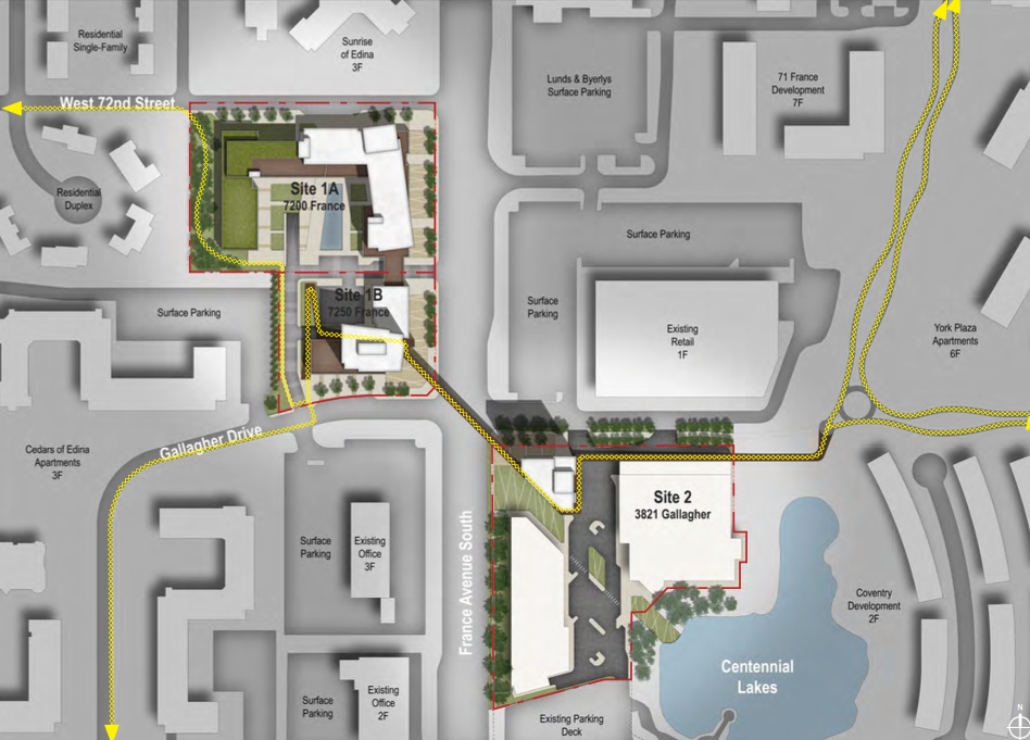
I think you're right. I've never biked this trail, but I use a lot of other trails and having this one make several sharp turns to gain elevation before crossing France traveling from East to West would probably make me just wait at street level. Crossing at street level is more direct and highly visible. Even people biking at higher speeds (the lycra crowd) wouldn't enjoy the bridge because of sharp turns and path crowding through the elevated patio areas.To me, this screams "we have two parcels that aren't in the best location relative to each other and the trail, but it would look cool in our proposal if we could throw a bridge over this intersection so let's hope no one notices we made the trail way harder to use".
I was thinking of that too. I mean, yeah, the aerial view makes it clear this proposed trail is pretty much a cluster, but I gotta say when I weave through the Sabo bridge area, I never even really think about it. When I think about behavior on the ground, I don't think I'd divert to the street here, I think I'd just meander through without giving it much of a second thought (well, maybe if it was raining...).Yeah, I was going to say, the Sabo Bridge requires elevation, a road crossing, and at least one sharp turn (if you're either coming from or turn onto the Hiawatha Trail into downtown). This bridge isn't that different. It even looks like the Sabo Bridge!
I assumed that they took the look of the sabo bridge for this rendering specifically so people would make the connection.Yeah, I was going to say, the Sabo Bridge requires elevation, a road crossing, and at least one sharp turn (if you're either coming from or turn onto the Hiawatha Trail into downtown). This bridge isn't that different. It even looks like the Sabo Bridge!
Users browsing this forum: No registered users and 1 guest
