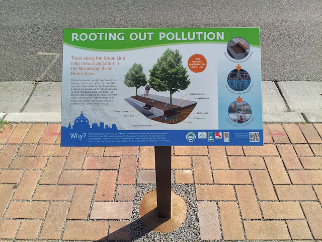
On my way home this evening, I saw this sign put in by the local watershed district describing the 5-mile tree trench system used for runoff mitigation along University Avenue.

The enclosed portion of the bridge is exactly 0.25 miles. Blegen to the Rec Center is only a bit over 0.5 miles. It's just a mile from Blegen to the far side of the stadium. The average adult walks about 3.5 mph so yeah, pretty much everything on the main campus is within a 15 minute walk from pretty much anywhere else.Unless you're on crutches, you really should be able to walk from Blegen to Keller in 15 minutes pretty easily. I was a campus tour guide for three years and have a pretty decent sense of (forwards and backwards!) walking distances on campus...you ought to be able to walk from Hanson Hall at the bottom of the West Bank to Folwell Hall at the top of the East Bank in less than 15 minutes.
#9 Bridge would probably make it work!Try Carlson to Folwell in 15 minutes by foot, ain't happenin'!
I'll got time to kill on Friday. I'll test both routes, though I doubt Bridge #9 will be quicker than Washington Ave. It might be a shorter distance, but there's a fairly significant elevation change.Maybe. I doubt it's any faster than taking Washington.
I plunked CSOM to Folwell into Google Maps's pedestrian mode and it spit out a time of 18 minutes. Google's algorithm seems to be slightly faster than I can walk (at least when it's calculating walk time for transit directions), so it may be pretty tight. But hey, this calls for a real-world experiment!
Users browsing this forum: No registered users and 0 guests
