Riverview Corridor Streetcar
Re: Riverview Corridor
Actually I've been assuming Riverview will be lrt and write my comments above assuming as much. I think the red line is irrelevant to the viability of Riverview or, in fact, anything transit related.
-
St. Studebaker
- Block E
- Posts: 5
- Joined: August 8th, 2014, 12:46 pm
Re: Riverview Corridor
Don't jinx it. A BRT would be devastating.
Re: Riverview Corridor
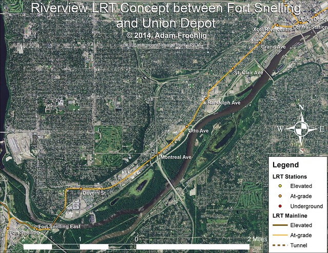
Here's what I've fleshed out for the Riverview Corridor, utilizing concepts I discussed earlier in the thread:
Re: Riverview Corridor
I don't know, taking it south of W. 7th around your proposed Otto Ave station means taking it away from a relatively dense residential area and dumping it where there aren't any people. By Montreal that's not as extreme but it still seems like you're moving it away from a lot of potential trip generators.
-
twincitizen
- Moderator
- Posts: 6405
- Joined: May 31st, 2012, 7:27 pm
- Location: Standish-Ericsson
Re: Riverview Corridor
Froggie, I love it and it fits perfectly the idea of a hybrid LRT / streetcar. It would run in mixed traffic from Randolph to 5th St downtown (e.g. where St. Paul has planned a streetcar line), though hopefully with some signal optimization to speed things up a bit. Dedicated ROW on West 7th just isn't in the cards, politically speaking. It's still a MNDOT street and St. Paul is quite conservative itself (resistant to change, not left vs. right).
The most glaring issue with your map is the total lack of stations! I'd split both "Davern" and "Montreal" into two separate stations. For Montreal, it would make sense to have stations placed roughly 1/2-mile apart, on either side of 35E (which creates a walkability divide). That way you serve the industrial area (Summit Brewing) on the east side, and the public/senior housing complexes on the west side of 35E. As for Davern, I think a case can very easily be made for two stations, to better serve the existing dense areas, rather than placing all your ridership hopes on redevelopment of Sibley Plaza, which will add a couple hundred new residents at most. A ped bridge or tunnel across/under West 7th would be nice to directly serve the newer apartments/condos (River Crossing) on the south side of 7th. Running in a dedicated guideway, adding another station adds less than a minute to the running time, especially when you're not dealing with additional traffic signals (like on University). This line is going to need all the ridership it can get to justify building rail, so I'd err on the side of more stations to capture as many potential riders as possible.
When considering ridership potential on this line, wouldn't a single-car LRV running at 10-minute headways be more than adequate? Take the existing ridership on the Route 54 bus (4,000 daily), the aBRT projection for 2030 (7,100) and maybe double those numbers. The Green Line more or less doubled ridership in that corridor, correct? More than doubling those ridership numbers gets you 15,000+ daily trips in 2030, and I still think a 90' LRV running every 10 minutes can do the job. I think that would be a very optimistic projection for this corridor. If we're talking about mixed-traffic between Randolph and downtown, I don't think you can realistically plan for anything bigger than a single 90' LRV. If it's a smashing success, you could later expand station platforms to handle two-car trains, but I just don't see that being necessary in the first two decades of operation.
I'm sure there are those who will tell me I'm wrong, and that a single-car LRV operation would be foolish, but I don't think I too far off. Perhaps the trains would get quite full during Wild Games (folks using the Ft. Snelling & 28th Av Park & Rides), but also remember that the arena's capacity is like 18,000, far less than a Twins or Vikings game. Also, it's still relatively cheap to park in St. Paul. Downtown St. Paul isn't really growing as an employment center, and has lots of existing space to fill. The line would potentially draw suburban commuters from the aforementioned park & rides, but would otherwise be reliant on mostly low-to-medium density residential areas for ridership, though there are several large apartment complexes along the route.
For reference, B-Line study summary: http://www.metrotransit.org/Data/Sites/ ... st_7th.pdf
Also, fun dumb transit fact to make you mad: Route 54 travels from Terminal 1 to MOA Station in 11 minutes. It takes the Blue Line 13 minutes
Re: Riverview Corridor
It seems like single-car LRV would be a good option, and would keep costs down. The West 7th neighborhood is a geographically isolated part of the city, that doesn't have a terribly large amount of room to grow.
I will bet you a dollar that we'll see some St Paul elected official push for two-car trains, at least, if LRT is selected. "We wouldn't want someone at the Lindbergh Terminal station seeing a long train to Minneapolis and a short train to St Paul and thinking that St Paul is a secondary destination"
I will bet you a dollar that we'll see some St Paul elected official push for two-car trains, at least, if LRT is selected. "We wouldn't want someone at the Lindbergh Terminal station seeing a long train to Minneapolis and a short train to St Paul and thinking that St Paul is a secondary destination"
-
HiawathaGuy
- Wells Fargo Center
- Posts: 1635
- Joined: June 4th, 2012, 12:03 pm
Re: Riverview Corridor
Blue line has stops at Terminal 2, American Blvd, Bloomington Central and 28th before MOA. Route 54 only stops at 28th before going to MOA. So by avoiding Terminal 2, exiting at 34th and then following American Blvd to 28th Ave S to access the 28th Ave S. station, the bus achieves a 2 min improvement. I'd say that's not very impressive, given the train has 3 additional stops between Terminal 1 & 28th than Route 54. But it's understandable.Also, fun dumb transit fact to make you mad: Route 54 travels from Terminal 1 to MOA Station in 11 minutes. It takes the Blue Line 13 minutes
-
HiawathaGuy
- Wells Fargo Center
- Posts: 1635
- Joined: June 4th, 2012, 12:03 pm
Re: Riverview Corridor
I realize that this is completely hypothetical on your behalf, but I honestly don't think it's anywhere close to reality. Rail line lengths all over the world are dictated by ridership. It's certainly not uncommon to see one line have more cars than another in places like here, where we don't have the ridership to justify long trains running everywhere."We wouldn't want someone at the Lindbergh Terminal station seeing a long train to Minneapolis and a short train to St Paul and thinking that St Paul is a secondary destination"
-
twincitizen
- Moderator
- Posts: 6405
- Joined: May 31st, 2012, 7:27 pm
- Location: Standish-Ericsson
Re: Riverview Corridor
I mostly just wanted to point out that a Riverview LRT would likely be slower between those two busy stations than the bus is today. A little further up the line, the curves to maneuver around Ft. Snelling and track switching will have to be done at lower speeds as well, while the 54 uses Hwy. 5 at 55-60MPH (albeit in a lengthier circuitous route). When all is said and done, LRT is not going to be much faster endpoint-to-endpoint than the Route 54 . The B-Line was only going to shave 2 minutes off the total trip, after adding off-board fare collection and perhaps passive signal priority. The exclusive ROW portion south of Randolph is where the LRT wins, but I don't think it's enough to gain more than a couple minutes over what the B-Line would have done. If this can be built for a reasonable cost per rider and doubles the existing ridership in the corridor, that's a good sign. It certainly looks like a better investment than any BRT line that touches Washington County (Gateway, Red Rock). If this thing comes in under $1B, it should advance quickly. To its benefit are the higher-than-projected ridership numbers on both of our existing LRT lines, showing that our region has a strong rail bias. Planners should be able to massage those ridership numbers up to at least 15,000 trips/day.Blue line has stops at Terminal 2, American Blvd, Bloomington Central and 28th before MOA. Route 54 only stops at 28th before going to MOA. So by avoiding Terminal 2, exiting at 34th and then following American Blvd to 28th Ave S to access the 28th Ave S. station, the bus achieves a 2 min improvement. I'd say that's not very impressive, given the train has 3 additional stops between Terminal 1 & 28th than Route 54. But it's understandable.
-
HiawathaGuy
- Wells Fargo Center
- Posts: 1635
- Joined: June 4th, 2012, 12:03 pm
Re: Riverview Corridor
Very much agreed.Yeah, I mostly wanted to point it out that a Riverview LRT would likely be slower between those two points than the bus is today. The curves to maneuver around Ft. Snelling and track switching will have to be done at lower speeds as well, while the 54 uses Hwy. 5 at 55-60MPH (albeit in a circuitous route). When all is said and done, LRT isn't going to be a great deal faster than the Route 54. The B-Line was only going to shave 2 minutes off the total trip, even after adding off-board fare collection and perhaps passive signal priority. The exclusive ROW portion south of Randolph is where the LRT wins, but I don't think it's enough to gain more than a couple minutes over what the B-Line would have done. If it can be built for a reasonable cost per rider and doubles the existing ridership in the corridor, that's good enough for me. It certainly looks like a better investment than any BRT line that touches Washington County (Gateway, Red Rock). If this thing comes in under $1B, it should advance quickly.
-
mister.shoes

- Wells Fargo Center
- Posts: 1300
- Joined: November 26th, 2012, 10:22 am
Re: Riverview Corridor
I like your map, froggie. I'm sure there's a reason why you use W 7th from Smith to 5th, but I really liked the idea someone had to run the line on Smith for that segment. I don't have any real justification other than "it just feels right, given the constant congestion on 7th." I'd add one additional station, too, so there'd be three in the space of your two: West 7th/Smith, Smith/Chestnut, 5th St behind Roy Wilkins instead of behind Xcel.
The problem with being an introvert online is that no one knows you're just hanging out and listening.

Re: Riverview Corridor
I agree with Froggie's routing. Routing on West 7th between 35E and Randolph would likely add a lot more to the cost than it would to accessibility. It's just over a mile between 35E and Randolph, so you really wouldn't want to squeeze any more stations in, and the only one of the three that would benefit much from being closer to West 7th is Otto.
I also like the more northerly location for the Davern station, although if the Edgecumbe approach needed to be elevated too high it might be better to run it on West 7th.
I also prefer a Smith alignment in the 7 Corners area but it doesn't have a chance with all those parking ramps there and likely the Opus development will make the turns impossible from 5th St.
"Who rescued whom!"
-
mattaudio
- Stone Arch Bridge
- Posts: 7768
- Joined: June 19th, 2012, 2:04 pm
- Location: NORI: NOrth of RIchfield
Re: Riverview Corridor
Wow, true, Smith Ave is a likely casualty of the way the Opus megablock is being planned.I also prefer a Smith alignment in the 7 Corners area but it doesn't have a chance with all those parking ramps there and likely the Opus development will make the turns impossible from 5th St.
-
mattaudio
- Stone Arch Bridge
- Posts: 7768
- Joined: June 19th, 2012, 2:04 pm
- Location: NORI: NOrth of RIchfield
Re: Riverview Corridor
If a 7th Street alignment is actually considered east of Otto or Randolph, we're presented with the choice of having shared ROW (awful idea for streetcars, worse idea for part of our LRT network) or gutting the ROW for dual track LRT with little space for people, parked cars, moving cars, etc.
But these compromises aren't as harsh with gauntlet track in dedicated ROW through this section of West 7th. Instead of roughly 30' of the ~56' curb to curb being occupied by tracks, we could have 16' gauntlet ROW in the center. This would leave room for parking on both sides, or bike lanes on both sides with parking on alternating sides.
http://www.streetmix.net/-/171463
Re: Riverview Corridor
To run LRT in dedicated lanes and still have two-way vehicle traffic plus sidewalks and space for a left turn lane or stations, you need at least an 80ft right-of-way. West 7th has this. Smith Ave doesn't...it's mostly 64ft. Nor does Penn Ave, which is a big reason why that route was dropped from consideration for the Bottineau line.
Now it would be possible to restrict Smith Ave to one-way, which when combined with eliminating the boulevard would make possible running LRT, albeit with narrow station and sidewalk widths. It might also be possible (but very difficult) to eliminate vehicle traffic from Smith Ave. However, either option would certainly require West 7th St to remain 4 lanes to handle the traffic diversion. Keeping LRT along West 7th would enable both streets to function adequately with 2 lanes each.
Also, doing a quick check, virtually the entire United Hospital complex is within a 1/4 mile walk of a station along West 7th.
Could a routing along Smith Ave be done? Perhaps. But I just don't see it being worth the extra trouble and complexity.
-
mattaudio
- Stone Arch Bridge
- Posts: 7768
- Joined: June 19th, 2012, 2:04 pm
- Location: NORI: NOrth of RIchfield
Re: Riverview Corridor
My concept for Smith Avenue, definitely a fetishmap, was a cut and cover tunnel. Either emerging at Cliff Street, or turning under 7th and heading westward. It was based on the potential assumption that dedicated LRT right of way would not be possible anywhere on West 7th. I don't think I ever proposed at-grade LRT on Smith.
Re: Riverview Corridor
The potential issue with tunnels is that, assuming flat terrain and a 6% grade (max continuous grade for LRT), you need a minimum of about 650ft of length for the tunnel portal. Going with a flatter grade would require a longer distance.
Re: Riverview Corridor
A few more comments:
Regarding stations, I intended this more as true LRT rather than a "hybrid". For that reason, I didn't want it to get bogged down by too many stations. I use the Green Line as an example for this.
A station could easily be added somewhere between Davern and Montreal when/if that area redevelops (I looked at Rankin St initially). But given the predominantly industrial use, I just didn't see a station as viable there in the short-term.
I also toyed with the idea of a station in the vicinity of Shepard Rd and the south end of Edgcumbe.
Regarding woofner's concern at Fort Rd/Edgcumbe, I field-checked the area when I was in town a couple weeks ago, and I think my idea is doable. My concept was to bridge it over Fort Rd, effectively meeting Shepard Rd "at-grade", and I agree with matt's earlier concept of a 2nd deck atop the existing river bridge...which in my proposal would hold not just a bike/ped path but also the LRT. Would likely require significant strengthening of the river bridge, but I think it would ultimately be cheaper than a new bridge, plus I believe it would have the least impact on both the river viewshed and on the historic fort.
Nate Hood had a recent Streets.MN post where Riverview got mentioned and, while I don't agree with him on taking it squarely down West 7th, I agree with his comments regarding dedicated right-of-way, connecting the airport to downtown St. Paul, and using the Ford Spur (what I don't use for my concept) as a rail trail.
-
mattaudio
- Stone Arch Bridge
- Posts: 7768
- Joined: June 19th, 2012, 2:04 pm
- Location: NORI: NOrth of RIchfield
Re: Riverview Corridor
Did anyone propose a second deck on the Fort Road bridge that wouldn't carry LRT?
Re: Riverview Corridor
I know you'd mentioned a 2nd deck in the past for the bike/ped path. Wasn't sure at the time if you also intended it for transit as well.