I've made some revisions to my earlier concept:
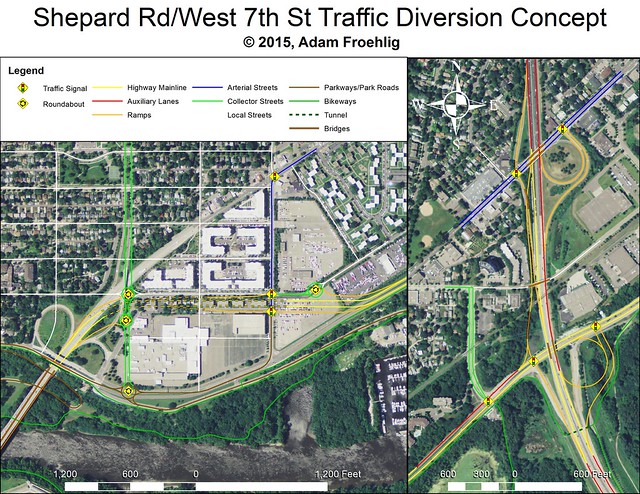
I keep a similar concept to what I had before, with a half-interchange at Edgcumbe (which is extended to the river parkway), a full interchange at Davern, and both eliminating West 7th west of Davern and restoring the street grid. But instead of looping south of the Airport Parking ramp, I locate the connector just south of Norfolk Ave. I believe it can also be built to incorporate a lid over the highway between Edgcumbe and Davern, though for obvious reasons such a lid cannot also cover the ramps. Still, the block of lid between Edgcumbe and Wheeler should be able to accommodate air rights development.
I've also created a map showing land requirements and redevelopment parcels for my revised concept:

With this concept, slightly more land currently used for streets and roads becomes available for redevelopment (12.2 acres, shaded in orange) than is needed for the roadway concept (12 acres, mostly shaded in yellow). However, about 4 acres initially needed for construction can be recovered via the freeway lid, with about half of that becoming parkland/open space (shaded in green), and the other half becoming developable air rights (mentioned above).
The existing Norfolk Place apartments (which I believe fall under "affordable housing") could be replaced on the parcel behind Buca (shaded in light orange).
Under this concept, Buca (shaded in fuschia) would lose a few parking spots for the Edgcumbe extension, but would otherwise remain intact.
The Airport Parking ramp also remains intact, but could easily become part of a future redevelopement proposal.
I've included 2 of the blocks along West 7th west of Davern under "redevelopment" as they would lose street access under this concept (especially the Taco Bell at West 7th and Davern).